Bangalore to Sulthan Bathery
Bangalore --> 150km --> Mysore -- 60km --> Gundlupet -- 40km --> Muthanga -- 14km --> Sulthan Battery
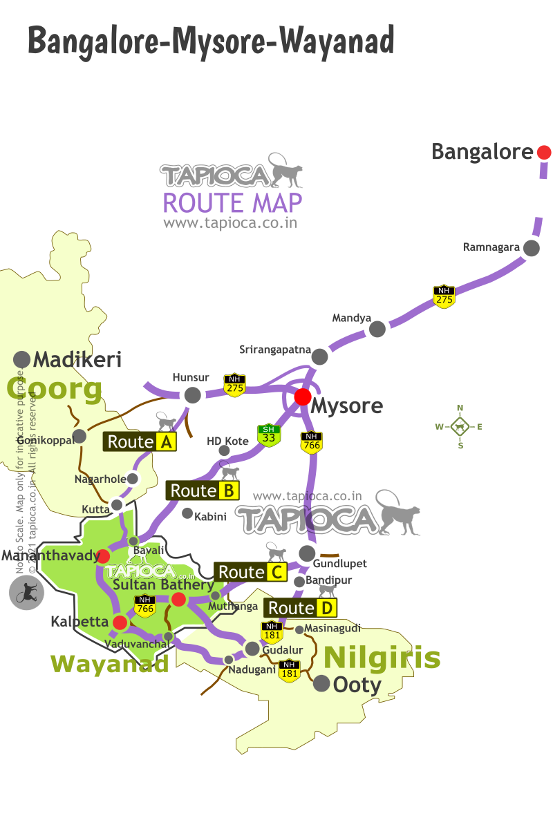
Bangalore to Sulthan Bathery This is about Route C shown in the route map shown below.
C
ompared to the other two routes (Route A & B), this is the popular (and busiest) route from Bangalore to Wayanad.For Route C, the travel plan till Mysore is more or less same. That is, take the SH17 from Bangalore up to Mysore ( see Bangalore to Wayanad)
At Mysore drive right through the city. You can easily get to NH 212 ( popularly called the Ooty road ) from the city center (palace area).
Of course there is the Outer Ring Road that acts like a bypass road around Mysore city. Better to drive through the city, as it is shorter, and quick way to reach the NH212 .
Mysore city to Nanjangud distance is about 23 km. Traffic is usually moderate to high.The road is 2-lane and in reasonably good shape. The speed of 60kmph seem to be the norm.
Apart from the potholes you have be a bit careful with those failed 'Michael Schumachers' on this road. Failed they are, but still capable of showcasing some marvelous piece of reckless driving on a busy road. Yes, we are talking about those buses in perpetual hurry.
You wiggle past Nanjangud town. Signboards are pretty clear and reasonably frequent. You will not make a wrong turn , neither will you have to ask for directions. From now on to Gundlupet, traffic slightly thins down, road is good and generally one pickups the lost time, that is if you have lost some.
Nanjangud to Gundlupet is about 35 km. In short, Mysore - Gundlupet distance you can cover in about 1½ hours, including a bit of city traffic delays. If we take a tally so far, Bangalore - Mysore - Gundlupet stretch takes 5 hours, including a lunch and tea breaks in between.
Gundlupet is a small town with a few eateries by the highway side. As you drive through the town, the highway makes a right turn as its exits the town. The straight road at this junction goes towards Gopalaswamy Betta , Bandipur, Mudumalai, Theppakadu, Masinagudi, Ooty etc. You should take the right turn that heads towards the Kerala border(towards Calicut).
Gundlupet to Sultan Bathery distance is about 50km, mostly through the forest. In about 15 minutes from Gundlupet, you’ll enter the forest. Then there’s a check post. Traffic is reasonably high, though not very heavy. Apart from the many private cars, this is a busy route with the interstate bus services and truck traffic. At the check post, private cars zoom past without much of formalities (unlike in the case of Route A or Route B).
It takes anything up to an hour till you cross the forest. Watch out for wildlife crossing the road. Inside the forest, the rules are again the same - no parking, no picnic, no horn etc .
A small river and a short bridge across it mark the Karnataka-Kerala border in the middle of the forest. In a stroke, signboards give way to Malayalam. It seems Kerala is in a self imposed competition with other states on who own the largest number of check posts. There is Forest Department check post, commercial tax check post, RTO check post and even a police check post.
Also, you will start getting the signs of road side teashops, in typical Kerala style. May be you can take the first bite of banana fried in coconut oil. And the Kerala style tea to wash it down. Tea in Kerala is measured (exactly arms stretch long! ) and delivered with a thud on the table.
Somewhere towards the end of the forest, you will see the entrance to the Wayanad Wildlife Sanctuary, as usual tourist vehicle makes a mess around the area. Take it as a cue for you to join the crowd or slip out and drive ahead to Sultan Bathery. Now you are well in the Wayanad heartland. Sultan Bathery to Kalpetta, the district capital, is 10 kilometers. From now onwards follow your tour itinerary for Wayanad.

Wayanad
Bangalore-Mysore-Coorg-Wayanad-Ooty Route Map
