Periya Pathai trail to Sabarimala
Details of the Erumeli - Pampa trail to Sabarimala. This is the traditional and most demanding trek trail pilgrims follow.

Western Ghats
Western Ghats
A
rrive at Erumeli by road or on foot. Erumely town is a significant place of the traditional trek route through the forest.Erumely
Erumely is the starting point of the traditional trail to Sabarimala. Devotees visit the mosque/mausoleum of Vavar Swamy situated in Erumely. It is believed that Vavar swamy protects devotees trekking through the Erumely trail. Pettathulal is a historic ritualistic dance held annually on the 27th of Dhanu (January) at Erumely.
Peroorthodu
You'll reach Peroorthodu,a stream-crossing the trail after 4km trek. This is the first traditional rest stop on this trail. Devotees bathe at Peroorthodu. Kanniayyappas (those going to Sabarimala for the first time) offers "Malarpodi" and "Aripodi", as a ritual before further trek.
Kalaketty
Kalaketty is 6 kilometres after Perurthodu. Kalaketty literally means the place where bull is tied. Legends says, Lord Shiva came on his bull and tied it to a banyan tree, to witness Ayyappa - his son - slaying demoness Mahishi. The shrine here is dedicated to Lord Shiva. As a ritual, pilgrims lighten camphor at this shrine.
Azhutha
Azhutha - a tributary of Pamba River - is 2km from Kalaketty. This is a major stop on the trail with facilities to take rest. The opposite side riverside is known as the 'Azhutha-medu' is a steep slope. As a tradition pilgrims pick a small pebble from Azhutha and proceed for the steep climb.
Kallidamkunnu
The steep Azhutha-medu trek ends at the top of Kallidamkunnu after 3.5 km trek fromAzhutha. Literally, Kallidamkunnu mean the place where stone (pebble) is left behind. As part of the customs, the devotees leave pebble taken from Azhutha river and drop at Kallidamkunnu. This is ritualistically to cover the remains of Mahishi. Each devote lightens a camphor here as a tradition.
Inchipparakotta
The shrine here is called Kottayil Sastha temple, dedicated to the Inchippara moopan, the guardian deity of the sacred forests.
Mukkuzhy
A downhill trek of about 3.5 km will bring you to Mukkuzhy at a valley. A temple dedicated to Devi.
If you are exhausted or unable to trek further for any reasons, this is the place you can get to a road. Mukkuzhy is next to the motorable road with a bus stand (Kuzhimavu bus stand) .
From Kuzhimavu, buses and taxis are available to Pamba (the nearest road point for Sabarimala). Regular bus services are available from Kuzhimavu to Mundakayam, a major town on the Sabarimala route.
Karimala
Karimala, meaning the Black Hill or the Elephant Hill is land inhabited by many elephants, they cross the trail often. You'll trek uphill and downhill alternatively for about 8km to reach a rivellet called Karivalanthodu. From here its a steep uphill trek of 5km to the Karimala Peak.
Overall you'ld ascent in 7 or 8 stages, each times reaches a flat terrain thinking that this is the peak, but not! After the 7th flat on the trail is the Karimala peak.
Karimala is the significant part of the trek.
Devotees often lights fire to escape from the wild animals and cold at Karimala peak. There is a traditional Nazhikkinar (a well inside a well) for the benefit of pilgrims. Karimalanathan (the protector of Karimala) and Karimala Bhagavathy (at the summit) for a risk-free journey.
Periyana Vattam
Also called Valiyana-vattom is where the steep Karimala hill ends. This is the abode of wild elephants. Periyanavattam literally meand the greater adobe (base) of elephants. Karimala peak to Periyanna Vattam is just under 5km trek downhill trek.
Cheriyana Vattom
Cheriyanavattam is the final rest stop just before Pamba, where the Periya Pathai trail ends. You are almost on the plains at the valley where the Pamba rives is visible any time.... 2.5km gentle trek will bring to the Pamba Riverbanks.
This is the conclusion of Periya Pathai trail and beginning of Neelimala trek - the final part of the trek - to Sannidhanam, the abode of Lord Ayyappa.
From Pampa , pilgrims who arrived by road will join for the Neelimala trek. This is a very busy trek route unlike the Karimala treak trail you've covered sofar.

Sabarimala
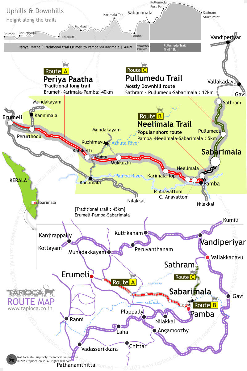
Periya Paatha traditional trail via Karimala to Sabarimala is about 40km to Pamba from Erumeli. Then follow the shorter 5km trail to Sabarimala from Pamba via Neelimala. Map shows the uphill/downhills along both the trails to Sabarimala

Sabarimala
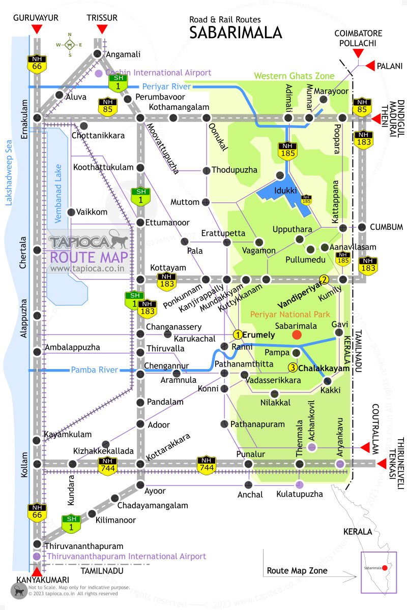
Rail and Road Routes to Sabarimala
