The Meesapulimala trek is worth integrating into a South Indian itinerary if you are an active individual seeking an isolated, high-altitude wilderness experience. Standing as the second-highest peak in the Western Ghats at 2,640 meters, Meesapulimala offers an environment highly distinct from the standard, heavily commercialized plantation walks found in Munnar. It provides a demanding 15-kilometer mountain trek across rugged montane grasslands and rare shola cloud forests. Unlike the nearby peak of Anamudi, which is completely closed to public trekking for strict conservation reasons, Meesapulimala remains accessible exclusively through regulated eco-tourism permits managed by the Kerala Forest Development Corporation (KFDC).
You must allocate one full day to this journey, as the logistics require a rough 4×4 jeep transit from Munnar to the base camp at Silent Valley, followed by roughly six to eight hours of active trekking. This experience is vastly superior to shorter, crowded viewpoint walks like Top Station or Lockhart Gap because it completely eliminates mass commercial crowds and places hikers directly on the high-altitude ridge dividing Kerala and Tamil Nadu. However, it should be skipped entirely by senior travellers, families with very young children, or anyone looking for a casual stroll. The steep terrain, lack of paved infrastructure, and complete exposure to shifting mountain weather mean that the physical investment is high, making it rewarding only for serious trekkers and outdoor enthusiasts.
Top 10 Reasons to Experience the Meesapulimala Trek
- Exclusive Regulated Wilderness Access: Because the KFDC strictly limits the number of daily permits allowed on the mountain, Meesapulimala remains free from the mass tourism that crowds other Munnar viewpoints. This regulation ensures a quiet wilderness trail where you rarely encounter other hiking groups.
- The Rhodo Valley Ecosystem: The high-altitude valleys along the trail are home to native Rhododendron arboreum trees, which bloom with bright crimson flowers between January and March. This specific flora is highly uncommon at lower tropical elevations, making the visual landscape distinct from lower-altitude Western Ghats paths.
- The Living Shola Forest Crossings: The trek cuts directly through ancient, stunted tropical montane cloud forests known as sholas. These dense patches of forest nestle in the valleys between the grasslands, featuring moss-covered branches and distinct microclimates that drop noticeably in temperature.
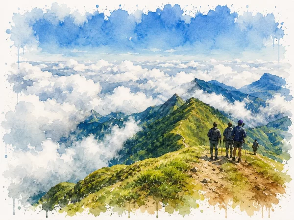
- The “Sea of Clouds” Sunrise Phenomenon: Trekkers who opt for an overnight stay at the base camp can reach the ridges by dawn to witness a vast, low-lying blanket of mist covering the lower valleys. This morning thermal inversion creates a stark visual boundary where only the highest mountain peaks pierce through the clouds.
- The High-Altitude Border Ridge Path: Walking along the upper ridges places you directly on the geographical and political boundary separating Kerala and Tamil Nadu. The trail offers two completely different vistas simultaneously: the forested hills of Munnar to the west and the sheer drop down into the arid plains of Tamil Nadu to the east.
- High Probability of Endemic Wildlife Sightings: The remoteness of the trail increases the likelihood of observing rare endemic species, particularly the Nilgiri Tahr (a mountain goat species native to these hills). Unlike Eravikulam National Park, where visitors view the animals from a paved road, encounters here occur in a wild, unmanaged habitat.
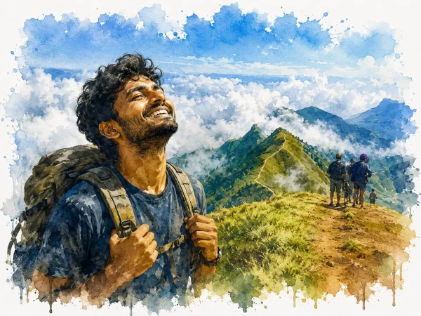
- A Physically Demanding, True High-Altitude Trek: With an altitude gain that pushes up to 2,640 meters, this is a genuine endurance test. It provides an ideal progression for hikers looking for a challenging mountain route in South India that requires sustained aerobic effort without needing technical climbing gear.
- The Scenic 4×4 Off-Road Jeep Approach: The journey to the starting point of the trek via a rugged, unpaved track through the Silent Valley tea estate is an experience in itself. The 4×4 transit navigates deep ruts, stream crossings, and steep inclines, filtering out casual vehicles and framing the isolation of the trek.
- Unspoiled Visual Textures for Landscape Photography: The combination of windswept mountain grasses, sharp rocky outcroppings resembling a tiger’s whiskers (from which the mountain derives its local name), and moving walls of fog provides dynamic, constantly shifting conditions that challenge and reward photographers.
- Direct Contribution to Local Conservation: Because the entire operation is run by the forest department using local community guides, your permit fees directly fund anti-poaching patrols and community-led conservation initiatives, ensuring your tourism spend supports the preservation of a fragile ecosystem.
Signature Experiences
- Boarding a rugged 4×4 jeep in the cold, pre-dawn darkness of Munnar to navigate the rocky, unpaved mountain tracks up to the Silent Valley base camp.
- Stepping from the dense canopy of a moss-draped shola forest directly into the vast, open expanses of the high-altitude grasslands.
- Pausing on the high mountain ridge to watch the rapid ascent of a wall of mountain mist swallowing the trail within a matter of minutes.
- Spotting a herd of endangered Nilgiri Tahr grazing on the steep, rocky precipices near the main peak.
- Standing at the 2,640-meter summit stone to take in an unobstructed, 360-degree panoramic view of the entire Western Ghats range.
- Walking past the unique pink-and-red blossoms of wild Rhododendron trees scattered throughout the upper valleys in the early months of the year.
- Drinking fresh, cold mountain water directly from an alpine stream under the guidance of a local forest department tracker.
- Experiencing the dramatic temperature drop and whistling high winds while standing on the exposed border line of the peak.
- Looking down from the summit to spot the distant waters of the Anayirangal Dam gleaming in the valley far below.
- Listening to the complete silence of the remote mountain high plateau, broken only by the wind and the occasional call of mountain birds.
Highlights Along the Journey
Silent Valley Tea Estate
The initial jeep transit winds through this historic, high-altitude tea plantation. The neatly manicured green carpets contrast sharply with the wild mountain terrain that begins immediately where the estate ends.
Rhodo Valley Base Camp
The highest point accessible by vehicles, situated at roughly 2,200 meters. This functional mountain outpost serves as the final briefing point before trekkers enter the protected forest zones.
The First Ridge
The first major incline opens up onto a sweeping ridge trail. This section tests a trekker’s pacing and offers the first expansive views looking back toward Munnar’s lower hills.
Shola Forest Pockets
The trail dips periodically into deep, damp depressions filled with native montane forest. These segments provide welcome shade from the intense high-altitude sun but require careful foot placement over slick tree roots.
The Tiger’s Whisker Outcropping
A distinctive series of sharp, parallel rock ridges near the summit that give Meesapulimala its name. These formations require a short, steep scramble and mark the final approach to the true peak.
The Summit Cairn
The absolute highest point accessible on the trek. It features a simple stone marker and provides a vantage point from which you can look directly across toward the towering, protected mass of Anamudi Peak.
Nearby Attractions & Combinations
| Attraction | Distance | Why Combine It |
|---|---|---|
| Eravikulam National Park | 40 km | Allows you to compare a highly structured, paved conservation sanctuary with the raw, unmanaged wilderness trails experienced on Meesapulimala. |
| Anayirangal Dam and Lake | 35 km | A scenic reservoir surrounded by tea gardens and elephant corridors, providing a relaxing, low-effort afternoon drive after a strenuous day of trekking. |
| Top Station Viewpoint | 45 km | Offers a panoramic lookout over the plains of Tamil Nadu accessible by road, making it a good alternative for companions who cannot manage the Meesapulimala hike. |
Best for Different Travellers
| Traveller | Why This Experience Suits Them |
|---|---|
| Backpacker | The shared trekking options and basic dormitory tents provided by the forest department offer an affordable way to access world-class mountain wilderness. |
| Budget Traveller | Because the package includes guides, transit, and basic access, it keeps costs entirely predictable with zero hidden commercial tourism fees. |
| Couple | The absolute isolation of the mountain ridges and the shared challenge of the steep climb offer a memorable, uncommercialized adventure away from busy tourist towns. |
| Family | Generally unsuitable due to the long distances, lack of toilet facilities along the trail, steep elevation changes, and challenging weather variations. |
| Photographer | The dramatic juxtaposition of crisp mountain ridges, moving walls of fog, and rare high-altitude flora offers world-class raw landscape compositions. |
| History Lover | Of minimal interest, as the experience is almost entirely centered on natural geography, microclimates, and montane ecosystems rather than human heritage. |
| Nature Lover | An absolute priority. The opportunity to walk through pristine, undisturbed shola-grassland complexes and view endemic wildlife in its true habitat is unparalleled in South India. |
| Luxury Traveller | Unsuitable unless you are willing to compromise on comfort. The available accommodations at the base camp are basic eco-lodges or tents focused on utility over luxury. |
| Slow Traveller | An excellent fit if you opt for the multi-day stay options at the KFDC camps, allowing you to acclimatize, birdwatch, and explore the mountain tracks without haste. |
| Weekend Traveller | Highly efficient if coming from nearby urban hubs like Kochi. You can arrive in Munnar on Friday night, trek Meesapulimala all day Saturday, and return by Sunday evening. |
Ratings
| Factor | Score (1–10) |
|---|---|
| Scenic Appeal | 9 |
| Overall Experience | 9 |
| Authenticity | 10 |
| Activities & Engagement | 8 |
| Crowd & Comfort | 5 |
| Accessibility | 4 |
| Time Efficiency | 7 |
| Budget & Value | 8 |
| Weather Dependence | 10 |
| Uniqueness | 9 |
Overall Score: 79/100
Meesapulimala earns an exceptional score for raw authenticity, visual landscape value, and its strict preservation of an uncrowded wilderness environment. However, its overall score is lowered by its poor accessibility, basic comfort levels, and absolute dependence on the weather, as heavy mountain fog or intense rain can completely erase the views and complicate the trek.
Who Should Experience It?
Perfect For
- Trained hikers and backpackers seeking a demanding, multi-hour mountain route that tests physical stamina.
- Wilderness purists who want to escape commercialized tea garden tourism and experience undisturbed indigenous ecosystems.
- Landscape photographers who are willing to wake up before dawn and brave harsh conditions for distinct, fog-framed mountain imagery.
Less Suitable For
- Casual tourists looking for an effortless, vehicle-accessible viewpoint to take quick photographs without walking.
- Families travelling with small children, elderly individuals, or anyone experiencing knee or joint pain that limits downhill walking.
- Travellers who expect high-end luxury hospitality, fine dining options, or modern resort amenities at the end of the day.
Practical Information
- Ideal Duration: One Full Day. The journey requires roughly two hours of vehicle transit to and from Munnar, combined with six to eight hours of mountain trekking.
- Best Season: October to February. These winter months provide crisp morning air, clear skies for panoramic views, and manageable daytime temperatures. June to September should be avoided completely due to heavy monsoon downpours that turn the trails into slick mud and introduce heavy leech activity.
- Best Time of Day: Pre-dawn start. Leaving your base or Munnar town by 4:30 AM is essential to clear the checkpoints, manage the off-road drive, and scale the first ridge before the intense midday heat and afternoon cloud cover roll in.
- Budget: Moderate. The cost is tied strictly to the mandatory eco-tourism permits, guide fees, and 4×4 jeep hire fees stipulated by the forest department, which generally run between 3,000 to 5,000 INR depending on whether you choose a day trek or an overnight stay package.
- Booking Advice: Advance booking is absolutely mandatory. Because the Kerala Forest Development Corporation (KFDC) strictly limits the daily foot traffic to preserve the environment, slots during weekends and peak winter months sell out weeks in advance via their official online portal. Do not show up at the base camp expecting spot registration.
- Accessibility: Poor. The trek is entirely inaccessible to wheelchairs, strollers, or individuals with mobility issues. Reaching the trail requires a private 4×4 vehicle capable of clearing deep ruts, and the mountain paths consist entirely of raw earth, loose gravel, and steep rock scrambles.
- Suggested Itinerary Integration: Insert this experience into the middle of a wider Kerala trip. Spend your first day arriving in Munnar and exploring the lower tea gardens to acclimatize. Dedicate the entire second day to the Meesapulimala trek, and reserve the third day for a low-intensity drive down toward the Periyar wildlife sanctuary or the Alappuzha backwaters to let your muscles recover.
- Common Mistakes: Wearing casual running shoes or sneakers with smooth soles, which leads to dangerous slipping on the steep, grassy downhills; failing to pack sufficient drinking water and high-energy trail snacks, as there are zero commercial stalls once you pass the base camp; and ignoring the guide’s advice regarding rapid weather changes, which can result in getting disoriented in thick mountain fog.
- Travel Tips: Dress in layers, as the temperature at dawn can drop close to single digits, while the midday sun on the unshaded ridges is intense. Pack a high-quality raincoat even in the dry season, apply anti-leech powder or high socks if trekking close to the shoulders of the rainy season, and ensure your camera and phone batteries are fully charged, as the cold high-altitude air drains electronics rapidly.
Final Verdict
The Meesapulimala trek serves as a powerful reminder that South India possesses raw, challenging mountain environments that rival lower Himalayan paths in visual scope. By enforcing a strict cap on daily visitors, the forest department has successfully insulated this high-altitude ridge from the commercial noise and litter that plagues much of Munnar. The resulting experience feels isolated, demanding, and deeply connected to the distinct montane ecology of the Western Ghats.
However, the significant physical effort required to complete this 15-kilometer mountain route means it is fundamentally not a crowd-pleasing sightseeing trip. The rough off-road approach, the lack of basic trail amenities, and the total exposure to shifting wind, rain, and fog mean that you are earning every viewpoint through sustained physical exertion. If your travel goals focus on true outdoor adventure, this trek will easily stand out as the definitive highlight of your entire journey through Kerala.
Experience Meesapulimala if you are an active, fit trekker looking to challenge yourself on a remote, highly regulated mountain ridge that offers exceptional high-altitude grassland vistas completely free from commercial crowds.
Skip Meesapulimala if you prefer effortless vehicle-accessible viewpoints, travel with companions who have mobility limitations, or if you are unwilling to risk a strenuous eight-hour hike being obscured by sudden mountain mist.
Bottom Line: Meesapulimala trades commercial accessibility for pristine environmental isolation, offering a genuine high-altitude challenge that rewards physical stamina with unmatched views over the cloud-line of the Western Ghats.
Continue Exploring
Two iconic Kerala temples, two distinct experiences—compare Padmanabhaswamy Temple and Guruvayur Temple before you visit.
Choose Padmanabhaswamy Temple for royal heritage and grand architecture, or…
Alleppey vs Kumarakom
Choosing between Alleppey (Alappuzha) and Kumarakom depends on the kind…
Jeep vs Car at Munnar sightseeing
1. The “Jeep Sightseeing” Experience In Munnar, these are typically…
A jeep safari in Munnar is one of the most popular ways to experience the region’s rugged terrain, hidden waterfalls, and remote tea plantations that are inaccessible by regular cars.
Popular Jeep Safari Routes Key Details for Travelers Tips for…